 Support TT
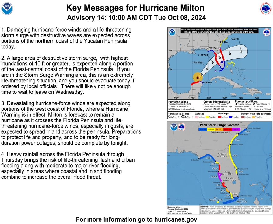
[Tuesday] Hurricane Milton to Bring Extreme Impacts to Florida Wednesday and Thursday
19 comments
« Previous Entry Next Entry »
Comments closed
Basic HTML is allowed.
Comments closed
Basic HTML is allowed.
Copyright © 2012- 2025 Tropical Tidbits, All Rights Reserved.
Contact: levicowan@tropicaltidbits.com
Privacy Policy: tropicaltidbits.com/privacy-policy.html
Comments
[…] Source link […]
Dr. Levi: Thanks for your insights on Milton.
Thanks for the update 💪
From everyone on the r/Hurricane subreddit, your videos and explanations are always appreciated! Thank you for your continued dedication to providing clear and meaningful tools to track life threating storms!
Thank you so much for your updates.
I’m up north, but I have a house in SRQ’s evac zone C, which got the alert to leave this morning.
My 93 yo mom is in zone D, but very close to us, so my daughter and her husband picked her up and took her down to North Port, where they’re far enough inland. (Lots of evac shelters around them, so we figure they’ll be safest there.)
This is terrifying and stressful and your calm assessment of the science helps make it bearable.
I cannot thank you enough for that!
LEVI: The correct date of the highest surge is 1848 when the Great Gale of 1848 hit Tampa Bay with a 15-foot surge.
The Hurricane of 1921 had the second highest at 11 feet.
It has been 176 years since a hurricane as strong as Milton hit Tampa Bay.
The X post incorrectly calls it the Tampa Bay hurricane; reference the front page article of 1848 which calls it the Great Gale.
I’m going to post another reference that correctly names the 1848 storm as the Great Gale of 1848.
On the plus side, you now have the correct highest surge (15 feet) and its date (1848).
Everyone, please correct the misinformation that the Hurricane of 1921 was the highest surge.
FYI, I’m a former researcher for the New York Times and the Miami Herald.
https://x.com/ChrisMartzWX/status/1843277566003548386
Meteorologist Mike Masco noted, “There is the potential for some additional increase in intensity through the day. The latest short-range high-resolution forecast models show a landfall in the #Tampa #StPete area by Wednesday night. This type of “direct hit” as well as intensity based on the going forecast has not been seen since 1848, when that hurricane was believed to be a category 4>.”
https://twitter.com/MikeMasco/status/1843321876292026817?ref_src=twsrc%5Etfw%7Ctwcamp%5Etweetembed%7Ctwterm%5E1843321876292026817%7Ctwgr%5Eeb7642a24a5ca15b453c337057e2ba119685f372%7Ctwcon%5Es1_&ref_url=https%3A%2F%2Fwww.zerohedge.com%2Fweather%2Fmilton-explosively-intensifies-major-hurricane-forcing-florida-declare-largest-evacuations
Preparations should already have been made, but if not you may find this new blog helpful: New
https://samiamproductions.com/wp/duality-lessens/ #BiggerPictureFocus
May God bless our loved ones in the free state of Florida. Thank you Dr Levi. Enjoyed the history by Mr Lamb. And bless the first responders.
The only place I’ve gone to for cyclone related information for as long as I can remember. It’ll be the only place I ever go as long as you’re pumpin out the info. So much better than the “other” guy who cant seem to go 2 hours without drinking alcohol. Appreciate all you have done over these years, and hope to see you around many more!
Also if you’re in the path of this storm BE SAFE (and I know its not always easy to just pack up and go…but… STRONGLY consider evacuating PLEASE)!
Thoughts and well wishes to all in the path of this historic hurricane.
As always, for me, the best trustable meteorological analisys, paired with NHC, thanks LEVI..
I’m listening to everything being said about this storm it’s a monster. I will probably get neg comments for this but I have to ask. does everyone believe this storm will lose strength to cat 3? cat 3 is still horrible but personally I believe they know they scared everyone and they know how bad it’s going to be so they had to tone it down to prevent chao. I believe it will a 5 and it’s going to be way worse than theyre saying.
be safe praying for all🙏🏼
#flordia
I kind of get the opposite feel. I believe they give the worst case so people will take it seriously. Look at Helene. The highest wine I saw recorded close to shore was 107 at buoy as I recall which was less than forecast. The surge forecast was 15-20 and the highest I saw was at Cedar Key and around 10 feet.
That being said, it is going to be a disaster and may be stronger that initially forecast, I just don’t think they are downplaying it at all.
Looking at the current HWRF model which historically has been pretty accurate regarding intensity but not track, it only shows a pre-landfall intensity of 951 mb(???), which would make it a Category 3 on the Saffir-Simpson scale. On the HWRF model, the minimum pressure was projected to be around 901 mb this morning(which is pretty darn close. I think it was measured at 907 mb by the Hurricane Hunters). But interestingly, the HWRF model is showing a steady increase of the minimum pressure to around 951 mb by landfall, again putting the storm around a Cat 3 at landfall. I know HWRF is just a model, but does anyone know what conditions would have the model steadily increasing the minimum pressure; maybe an anticipated Eyewall Replacement Cycle(ERC) or vertical wind shears? Any feedback is greatly appreciated.
Vertical shear; the NHC (nhc.noaa.gov) has been forecasting shear to weaken the system for a while and this is becoming apparent on satellite imagery. In fact, they’re forecasting the storm to begin extra-tropical transition as it nears the coast
Thank you for the response. The modeling makes sense then. I certainly hope that the landfall is a Cat 3 as projected. It’s not likely to change the storm surge, which is the real danger, but at least the wind damage might be less severe.
11am EDT NHC update has storm at 931mb
So you don’t think this weakening is due to another eyewall replacement cycle?
It was recently reported a 3-4 hours ago that Milton was undergoing Yet an Additional Eye-Wall Replacement Cycle as well as Growing in Overall Size!Just as Our Weather Forecasting Meteorologist Levi said would also Happen. Blessings and Safety to and For as many as is possible!