 Support TT
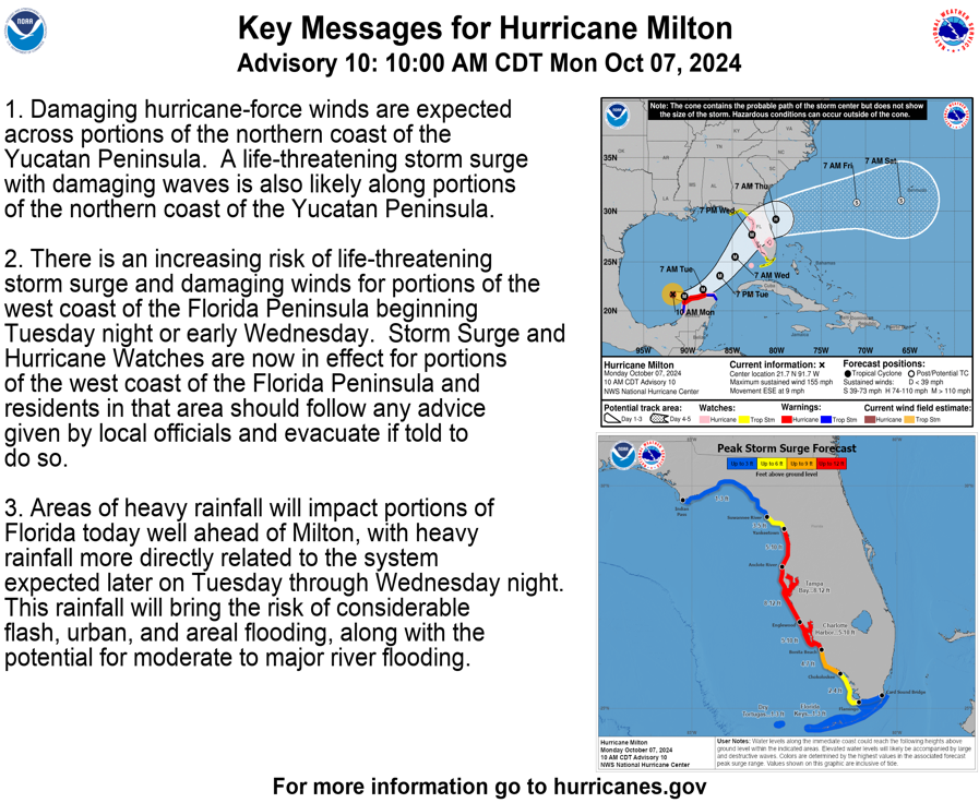
[Monday] Milton Becomes a Cat 5 Hurricane; Major Impacts to Florida Expected Wednesday & Thursday
22 comments
« Previous Entry Next Entry »
Comments closed
Basic HTML is allowed.
Comments closed
Basic HTML is allowed.
Copyright © 2012- 2025 Tropical Tidbits, All Rights Reserved.
Contact: levicowan@tropicaltidbits.com
Privacy Policy: tropicaltidbits.com/privacy-policy.html
Comments
[…] Source link […]
Appreciate all the info. Seems like it’s just a waiting game now, to see how slow it moves along Yucatan before making the turn as it heads north east. Still feels like “somewhere south of St Pete”, but who knows.
Sat just went down because so many people are watching Milton. 175/911 is crazy, and to think it could match Allen (1980) is crazy
Pardon my ignorance what does 175/911 mean?
I believe he’s referring to wind speed/barometric pressure
I live in Pinellas
If where you live has water to the east, you need to evacuate and get at least 10 miles inland of that. Plant City and points northeast should be good, since I-4 is less congested than I-75 north.
You mean to the west? Water to the east would be the east coast…
I think they mean if the literal Tampa Bay is east of you, as in you’re on the Pinellas peninsula
Gotcha – that makes sense. Former resident of east Hillsborough County, glad I’m no longer there. The place is bordering on getting wiped off the face of the Earth. Thoughts and prayers for those who remain.
Legit you can’t live in Pinellas without having both east or west of you
Me too! Out of town now but supposed to fly back Saturday!
Thank you sir…you have no idea what the knowledge means to the layperson
They can prepare based on your guidance
Can you address Atlantic coast risks next time? Will it remain a hurricane as it crosses the peninsula? Is there significant risk of storm surge and evacuation orders around the Space Coast and north?
I’ve seen that Brevard County disaster prep folks are preparing for a low-end Category 1, so I guess they expect it will remain a hurricane during the entire crossing. Is there any chance it could sustain or rebuild to Cat 2 or 3 on the Atlantic coast?
Thank you so much for your work! You’re doing a great service to the public . I’ve told everyone about tropical tidbits! We’ve relied
On your science and forecast here in Sarasota since this past Saturday and it’s made such a difference in how we’ve prepared for Milton’s arrival. Only wish during the 48 hrs pre-hurricane we could get more frequent updates from you per day , but we’ll take anything we get and you’re able to share . Local meteorologist pale in comparison to your forecasting . My daughter’s a meteorologist from UM (Sea-Tacticts) and she turned us on to you . Please keep your incredible work coming !! From a lifelong Sarasota resident , thank you !
Lakeland wind impacts, what should we expect?
In case you decide not to leave. At least have a raft inside. A long time ago my area flooded. I had a raft inflated just in case. I was able to I float inside till it was safe to push geometry dash lite it outside to a safe area. Just a thought
Good work Levi as always. Your analysis is always greatly appreciated. If you’re in the path of this storm, you’ll want evacuate. It’s a no brainer. Stay safe, and good luck to all.
Nicholas – 175/911 indicates the maximum winds and minimum pressure of the hurricane
Thank you for your hard work!
I need your answer to this question in a positive spirit.