 Support TT
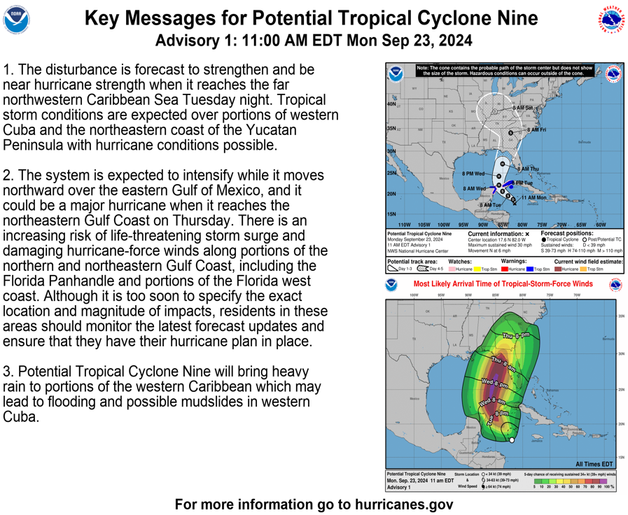
[Monday] New Storm in Caribbean Likely to Become Significant Hurricane in Eastern Gulf of Mexico
24 comments
« Previous Entry Next Entry »
Comments closed
Basic HTML is allowed.
Comments closed
Basic HTML is allowed.
Copyright © 2012- 2025 Tropical Tidbits, All Rights Reserved.
Contact: levicowan@tropicaltidbits.com
Privacy Policy: tropicaltidbits.com/privacy-policy.html
Comments
[…] Source link […]
we know that they have had the capability of steering these and making them Stronger by cloud seeding from drones. I’ve learned all of this from government websites. why don’t they share this with the public more? and since they can steer them and make them stronger, why don’t they stop? devastating what they do to people
cite your sources, make sure they end in .gov
Dr. Levi Cowan IS a Meteorologist, and has had this site since 2012. He IS a CERTIFIED tropical cyclone forecaster with the Joint Typhoon Warning Center.
It’s true. Ask me how I know …
This is far more complex than you’re leading on. There is a massive difference between creating artificial rain in UAE and dissispating a massive tropical system with a minimum pressure less than 900 mb, which this one could become. I am also quite sure the Cubans, Jamaicans, and governments of the Central American countries would not be keen on the US unilaterally changing the weather directly over their territories.
Also, if we can steer these storms, how do we decide where to steer them? Would rural less-populated areas get repeatedly slammed by Category 4+ hurricanes to spare bigger cities? How is that ethical?
Just because we can doesn’t mean we should.
It is ethical but firstly you’d dissipate the thunderstorms before they could form a storm, and second if you could steer storms you would just put them all out to sea and call it a day, with the only ethical drawback being the effects of that regarding drought and other weather systems affected by it.
To clarify-*It is ethical* I meant to say *It is an ethics issue*
Even if we could steer storms, we wouldn’t be able to do it as aggressively as you’d suggest, as natural factors would probably make a sharp turn impossible. This isn’t some cheap game, we’re talking about storms we still can’t forecast as accurately as we’d like, with properties we may not even know about.
Yea, maybe the Chinese are controlling the weather and causing billions of damage each year to our country and economy.
Yes, it’s absolutely true. They steer them with acupuncture.
Seek professional help. Take your meds.
Cloud seeding cooling the air to increase saturated vapor pressure. So, you are talking about cooling the air of several thousand square miles at altitude (at which temperature differential starts much cooler, thus a really cold substance you are dispersing). Tell me more about this website? Or maybe you could show me with a Sharpie?
Thank you Dr Cowan for your in depth analysis. I so appreciate and respect you.
I’m at FSU right now, attempting to follow in Dr. Cowan’s footsteps lol. This one should be interesting. Thanks as always for the incredible analysis!
Thank you just doesn’t seem adequately appreciative. Your analysis is so helpful in keeping me grounded and focused on preventive preparation rather than freaking out.
I’m scheduled to fly out of Pensacola on Thursday to visit family but definitely won’t leave my husband and dogs to fend for themselves if we end up in the cross hairs while I’m gone.
So, I am more anxious to get the final decision path locked in sooner rather than later.
Bless you for what you do!!
Fantastic summary as always!
Thank you, Levi.
I have followed you for a few years now and I really appreciate you sharing your knowledge. It helps knowing what to anticipate with these systems. My Florida family loves your posts, too.
Thanks Levi.. you are our “go to” for non-hype hurricane info. Always learning something from you. Know you are appreciated! Look forward to your update today.
Thank you Levi! I was surprised to wake up and see the storm still has no name & is still disorganized. Going to be a long couple of days for everyone along the FL Gulf coast. Thank you for your analysis, always comes use & to the point.
Apparent low-level center has migrated out from under the deep convection over the past hour or so and appears to have a significant southward component of motion (south of due west)…as if it’s simply advecting with the background trade flow. If this is the true center, will be interesting to observe whether additional deep convection develops near/over it in the coming hours as the shear continues to decrease. Will also be interesting to see if this presages a westward shift in the overall guidance envelope as vaguely alluded to in the 1500 UTC full advisory discussion from NHC.
Great Post Matt. Was just looking at the naked LLC myself and its apparent motion. As of 12:50EST the last couple of frames on the Hi res loop looks like convection is about to fire up on the NE side. The Euro conts to insist that this system does not reach major status. It keeps the system as a 980’s mb system give or take. The GFS which 24 hrs ago had it a 940’s beast of a major has been trending towards the euro in that it now has the system in the 970’s on approach over its last 4 runs beginning 18z yest.
Comparing both GFS and Euro…Looking at the upper levels I see a perfectly placed upper level jet streak placing our system in its right rear quad which is perfect for enhanced outflow and strengthening on both models as Levi pojnts out in yest video. I see overall shear around the system as it traverses the GOM NNE ward being minimal which should also aid strengthening on both. The SST’s are ripe for strengthening. So why then is the euro so insistent on not rapidly Deeping this system into a major? The only major difference I see when looking at the Euro and comparing to all the other models is the Relative Humidity charts at 700mb. It seems it has a less saturated system.
Im not saying the euro soln will be correct, but the trends in the modeling seem to point in this direction with regards to a “weaker” system than might otherwise be. I stress weaker because there are still many factors that support strengthening, but if drier air infiltrates as the euro suggests, all the other conditions could be perfect, the system will never reach its max potential which is fine.
To my eye, the circulation of Helene still appears fairly shallow…mostly low-level…and there remains evidence of 10-20 kts of southerly flow/shear…especially over the western semicircle due to the upper-low/trough to its west. The southward jog of the apparent low-level center of this morning appears to have ended with somewhat of a more northwestward track now resuming.
It appears that the storm crosses the axis of the Gulf loop current overnight Wednesday (hence the jump from cat 1 to cat 3 during that time). As it continues to gain latitude thereafter, it seems that it may begin to experience increasing west/southwest upper-level winds related to the larger circulation around the mid-latitude trough and embedded upper low over the lower-middle MS valley. Indeed, the positioning of the upper-trough/low appears subtly farther south and east in today’s 12Z high-res run of the GFS versus its 06Z and 00Z runs, and today’s Euro also has the upper-low a bit farther east compared to yesterday (albeit a bit north of the GFS position). Perhaps the upper-low is ending up a bit “too close” to Helene in the hours preceding landfall resulting in a leveling off of intensity (or perhaps even some weakening)?
Additionally, both GFS/Euro are showing significant dry air (500 mb RH<10%) impinging upon Helene from the west after it crosses the loop current and continues north-northeastward during the day Thursday. Given the expected large circulation envelope of the storm, some entrainment of this air seems reasonable which could result in some erosion of deep convection west/south of the center prior to landfall. The situation seems vaguely akin to many historic northern Gulf coast hurricane landfalls (Opal, Katrina, Rita, Ivan, etc.) and somewhat in line with observations reported by Rappaport, et al. (2010). The expected fast forward speed of the storm may mitigate some of the negative environmentals, but due to the increasing shear and dry air, it may end up very lopsided at landfall with hurricane conditions east of the center and comparably tame conditions west.
Will be most interesting to watch!
Thank you for what you do. I love how your not all hype and just a facts kinda guy. I found you many years ago in the jeff masters weather underground blog. So glad I did.